![]()
|
Lakes from Space |
Satellite sensors like the Thematic Mapper onboard the Landsat series of satellites (or the Enhanced Thematic Mapper, or ETM+, onboard Landsat 7, the latest in the series), measure the radiation reflected by land features. But they don't measure continuously over the infinite range of possible values (that'd be impossible). Instead, the engineers and scientist who design the sensors have to decide which range of values they want to measure, and this decision depends on what the sensor is primarily design to "see."
Landsat satellites are designed to see terrestrial features, rather that surface waters. So the TM (and ETM+) sensors are most sensitive to the range of radiance values encountered in features such as forests, agricultural fields, roads, urban areas, etc. This is what these sensors do best.
But that doesn't mean that
they can't "see" radiation reflected from surface waters. It
only means they are not particularly sensitive to that range of radiance.
This can be seen easily in the following images of the same area in North-Central
Wisconsin.
The image you see below corresponds to the "best" display for this section of a Landsat image. Terrestrial features are seen very clearly: deciduous and coniferous forests, forests clearings, roads, even wetlands. But lakes are just black holes in the landscape. But these are precisely the features we are interested in! How are we going to map water clarity from an image where all lakes are plain black?
Click on the buttons below:
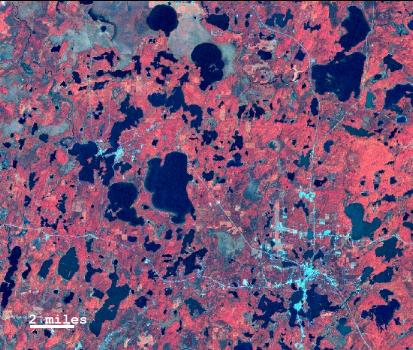
When you click on "Lakes", you can clearly see the lakes. And you can see that there is a lot of variability in the "colors" of the lakes. In both cases you are looking at the same Landsat image. And in both cases you are looking at the same bands -- the same portions of the electromagnetic spectrum. The difference is that in the second image we masked all the land features, and then we stretched the values recorded by the satellite sensor to span the full range of brightness values that you monitor can display.
The image of the lakes is very rich, which suggests that the satellite sensor captures a lot of information about the lakes. Some of that variability is related to optical properties of water, which is what we are interested in.
But that useful information is confounded by other factors that affect the characteristics of the radiation reflected by the lake surface. Things like lake depth (if the lake is too shallow, what you see is the reflectance from the bottom of the lake, not the water), presence of submerged, floating or emergent plants, and even the scattering of light by small waves if it was windy when the satellite captured that particular image.
Teasing apart the fraction of the variability that corresponds to water optical properties and the part that is due to other sources isn't an easy task. And that is what this project attempts to do!
|
On the SLOI web |
|
| |
What is SLOI? |
| |
Self-Help Program |
| |
Building a model |
| |
Lakes from Space |
| Other sites of interest |
| > Global Landsat images |
| > Landsat 7 over Wisconsin |
| > Earthshots: Satellite images of Environmental Change |
16 December, 2003
Web layout: Joan Riera, Sam Batzli
[what is SLOI][self-help][build a model][lakes from space]